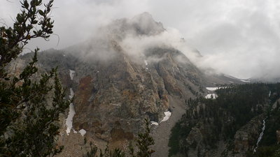
Clouds and Mount Williamson
For some time, I have been interested in doing a trip that would allow me to get a good look at the Great Western Divide. The concept of hiking over Shepherd Pass and then wandering west along the Kings - Kern Divide was attractive. Somewhere along the way, the idea of climbing Mount Williamson grabbed my attention, and I discovered that Mount Tyndall was "right there" also.
On trips like this, I like to keep a written log. I take time at rest stops and in camp to write down my thoughts about the trip and I transcribe almost all of these into these trip descriptions. I find my reflections made in the midst of the trip to be invaluable (and often reading them takes me right back to the time and place when I wrote them). I also realize that they are often the source of ideas for how I plan my next trip. So you have to suffer with these, maybe they will be of value to others besides myself.
I got up early, had a quick bite to eat and drove to the multi-agency center south of Lone Pine and was waiting at the door just before 8AM. There were only 4 of us waiting, so there seemed to be little question that I would get a walk-in permit for Shepherd Pass, and indeed I did. While waiting in line, I met a geologist named William Hirt from the College of the Siskiyous at Weed, California. He was a nice fellow and doing research on Sierra granites - he kindly offered to send me copies of some of the research papers he has written.
At 10:30 AM I had my pack on my back and was starting out on the Shepherd Pass trail. Weather was ideal: cloudy and cool with intermittent light rain. I met two young ladies (Michelle and Kathy) who were on their way up the trail with hopes of climbing Mt. Williamson. I hiked and chatted with them on the first push to the saddle, where they opted to make camp at about 2PM. I hiked on, figuring to camp just before dark and continued along the downhill section on the way to Mahogany Flat. To my amazement, I met a woman hiking out in a nice red dress (with Patagonia logo) - certainly seemed out of place talking to a lady in a dress on the side of a mountain. She was one of a group of biologists working for the USGS (biologists working for the geological survey?) who are doing plant community migration studies (no doubt related to climate change). She showed me a GoLite umbrella that she said had served her very well over the past several days of steady rain - and she says that it makes a wonderful sun shield as well.
I continued on through Mahogany Flat, Anvil Camp, and almost to the "pothole" where I made camp at the base of a snowfield under some firs. I had hiked about 10 miles in about 8 hours, climbing about 5000 feet, and my legs were getting so tired that they were reluctant to keep obeying commands to plod along. No rain at night. Nightime low was 40 degrees and I was a bit cold. No doubt exhaustion plays some part in this.
After crossing the snowfield I found myself on top of Shepherd Pass at about 10 AM. There I met two people (Corrine and Daryn) who were also just getting ready to climb Mount Tyndall. Up the three of us went (up the North Rib route). They set a brisk pace - the route was excellent (though it looks unlikely) and it was not long before we were on the summit. It turns out that these two are quite accomplished sierra climbers, having climbed all 248 peaks on the SPS peak list and now working on doing the list a second time. I had no idea the sort of people I was climbing with (though I did take note of their pace). They told me there is a 75 year old lady who is 3 peaks short of the 248 and still climbing. We did the descent to where I had ditched my pack, meeting two others on their way up. Rain started just as we parted ways (their parting words were: "better get somewhere and get a tent set up).
I began hiking into Williamson Bowl, which I had expected to be a nice stroll, but which in reality is a nasty sea of talus boulders. After one slip on a wet boulder and some thoughts of changing plans, I found an excellent campsite next to the first lake (12182) in the bowl and called it quits for the day.
After rigging my tarp, I enjoyed listening to raindrops and relaxing under it. It was only 3PM, but I was exhausted and it was pointless to carry a heavy pack across wet nasty talus to an uncertain camp location in the rain, and then back out again after climbing Williamson.
I am wishing I had a hang-up watch (I am using the clock in my camera), along with nail clippers. Also a separate hat is nice (I am relying on the hood of my hoody for sleeping warmth). I want to take extra measures to be cozy and warm when sleeping.
I got back to camp in time to meet two guys (Andy and Dave) from Laguna Beach. They camp nearby with plans to climb Williamson tomorrow. No sign of Michelle and Kathy. I am back about 5PM and spend another night in the same place. Since the sky is clear, I took down the tarp, but it was a cold night and the tarp might have added some warmth. It is just plain cold at 12,000 feet, even in August. I am reminded of the words in Porcella and Burns guidebook, "We have found 0 degree fahrenheit bags to be the minimum for "under the stars" comfort during the summer". I am getting by, but not cozy and comfortable.
I cross Tyndall Creek barefoot (many folks on the JMT carry "crocs" for stream crossings). Met and talked to a guy who was hiking the Muir trail with his son to celebrate his son graduating from college. They made it from Yosemite to here in 10 days (200 miles). I meet 7 JMT hikers at this crossing, then I am off the JMT and onto the Lake South America trail. Just as I am figuring that I won't see anybody on this trail, I run into Paul (aka "Booger"). He says he is just getting done spending 14 days alone, as he has done every summer in this area for the last 24 years. He says he sends his wife off on two trips each year to Europe, so she never gives him any flak. "I've been married for 43 years, and anyone who tells you that they understand women is lying!", he tells me. He is an amateur astronomer, lives in Ridgecrest, loves Death Valley. An interesting and nice guy. Carrying the book "Atlas Shrugged". Perhaps when I go solo I should carry a carefully selected book and not push as hard. So far this trip has been pushing to the limit each day, skipping lunch and snacks, but achieving my goals! Maybe next time I'll set easier goals and take it a little easier.
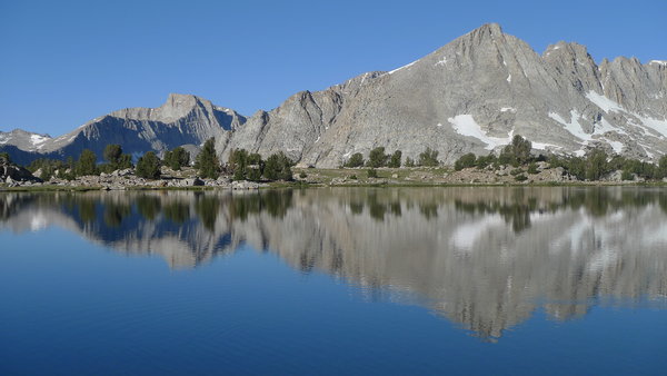
All of the travel from the Kern River Junction to Lake South America is difficult cross country travel. The trail is basically gone, although I was able to follow it in places. This is not a great tragedy though. As "booger" told me, the lake is pretty ugly. The lakes and country along the way though are beautiful. Lake South America is best admired (on a map) for its unusual shape. Amazingly enough the same thing could be said for Lake Italy much further to the north. I walked the short distance from my camp to where I could admire Lake South America (below me!) and called that good enough. Several ravens spent the night nearby - I may have camped at their usual roosting spot.
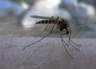
DEET may be mankinds greatest invention. I was wearing a mosquito headnet yesterday and glad to have it, but just two little drops of DEET and the mosquitos are leaving me alone for the day. At first I thought, "this stuff isn't working", but then I realized that although a cloud was still flying around me, they were not landing and biting! I do inhale one now and then when I get to breathing hard. The lakes below Lake South America are beautiful, but heavily infested.
After hiking for about an hour, the sun was warming things up and I stopped to peel off some clothes and make coffee and oatmeal. I put the quilt and tent in the sun to dry. I am now doing pretty nicely following the Lake South America trail (but it is tricky). With the discovery of DEET during breakfast, I am now laughing at the mosquitos.
Some conclusions:
I am trying to decide what to do. My worry is that Tyndall Creek may be too dangerous to cross at the Kern River, yet I would like to do a big loop through the Kern River Canyon. I have decided to abandon my ideas of climbing Milestone Mountain or any of the peaks along the Great Western Divide (Williamson and Tyndall are enough for this trip). I decide that the only thing to do is to hike down to Tyndall Creek, look it over, and if it is too dangerous, not do anything foolish and just hike all the way back.
Off I go.
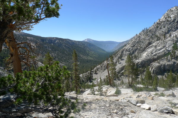
I am glad immediately. Below the trail junction there is a big dropoff with splendid views down the Kern River. The forest below is filled with wildflowers, and just being in the forest is soothing (but I am on the lookout for bears).
Serious horse traffic begins about a mile above Tyndall Creek. The trail looks plowed up. All of the down timber is cut. Clearly the park service are good buddies with the horse packers and make sure they can do their thing (a fellow I talk to tells me the packers he hires never carry a saw, and definitely never a chain saw).
The Tyndall creek crossing has a huge walk across log, and I never even take my shoes off or get them wet. Without the log it might have been feasible, but certainly would have been right at the limit. After I turn onto the Wallace Creek trail, there are great views down the Kern drainage. Wright Creek is a crossing with lots of fast water. I am carefully making my way across barefoot, and suddenly find another hiker in the water with shoes on, ready to offer me aid. No coincidence that he pops up at the only moment in the entire day when I might possibly have needed some assistance.
I drink 2 quarts of water, sure that this stream is not horse defiled. Wallace Creek is hot and south facing and I was going light and dry without water. I stop for an early pre-camp supper (and write my trip notes) - a pleasant and good idea. I switched to shorts at the barefoot crossing and the mosquitos are grateful.
I make camp below 10400 and could have a fire (but I don't -- I never do, and don't intend to make an exception tonight). Quite a contrast from my camp the night before. I have innumerable mosquitos for companions instead of the 3 ravens that roosted near my tent. I am under only the quilt, with one less layer and almost too warm. Last night I was in the bivy and wearing a down vest and was marginal, almost chilled, but was dead tired.
Without a headnet and DEET I would be going crazy with all the mosquitos.
Since I will be hiking the JMT for most of the morning, I make a project out of chatting with people on the trail about what where they are from, and what it is like to hike the Muir trail. I meet a couple from Alaska and ask them why they are hiking the JMT. They seem a bit puzzled at first, then tell me thay have been backpacking since they were very young, and then they began to exclaim about the beauty of the trail and how every part of it is different. His advice was to fly to Mammoth, take the YARTS bus to Yosemite, ship resupply packages to the usual places. Their longest leg between supplies was 10 days. They said to stay in a motel in Lone Pine and get a ride to Mammoth.
On the 4 mile stretch of the JMT I traversed, I met only about 12 people (including folks from New Zealand and Boston). Several others were doing a loop from Onion Valley to Whitney Portal, which seems to be a fairly popular thing to do. The one pass that was challenging was the north side of Mather Pass, which has the worst snow and ice. Some hikers had self arrest grips on their hiking poles.
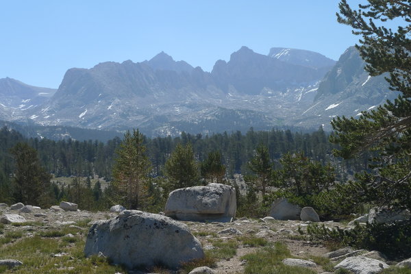
I met Bill Hirt (the geologist) on the Shepherd Pass trail. He was on his way to Lake South America to collect samples. I am admiring Thunder Mountain (just north of Table Mountain), it is quite the handsome peak from this direction. By 3PM I am at Shepherd Pass and figure I have plenty of daylight to hike out.
Going down Shepherd Pass, I realize that I have gotten a nasty sunburn on the back of my legs. The zip off shorts are great, but at these elevations an hour or two is plenty. I am feeling great till about Mahogany Flat, but then I am starting to feel that I have done enough hiking for one day, and after that things get more brutal. They day turns into 13 hours of essentially non-stop hiking. 10-12 miles is a sensible "hard day", but I am going for 21 miles. I get to my car at 8:45 as the light is all but gone. It took me 5:45 to hike the 12 miles down from the pass (almost exactly 2 miles per hour).
When I arrived at the truck, I was approached by a fellow at the trailhead who asked me about conditions. This fellow was Toby Guillette, who is into ultramarathons and ultra endurance activities of various sorts. His plan was to attempt to hike up Shepherd Pass, climb Tyndall and Williamson and get back to his vehicle the same day. He had his alarm set for 2:00 AM he said and I wished him well. Later I worried about him crossing the ice just before Shepherd Pass in the early morning when it was frozen hard. He has a website: Enduranceguy.com.
Checking his website later, I find he had "a rough go with the elevation so didn't try Mt. Tyndall too, as planned." His time to climb Williamson car to car was 19 hours, 20 minutes for 30 miles of distance and 10,000 foot elevation gain. Not too different from my total time on the move, but of course I spread my effort out over 3 days with 2 nights of sleep in the midst of it all.
While I was gassing up, I met another couple from Germany and remembered enough German to help them work out their gas purchase (they were perplexed by the requirement to pay before pumping).
I was on the road again at 10:30 AM, and arrived in Tucson about 10:00 PM after stopping for dinner at the Cracker Barrel in Buckeye, just northwest of Phoenix. I also found it no particular trouble to drive through Phoenix.
At the Lone Pine multiagency center before I head home. It is quite a zoo. I would say about 59 percent of Sierra visitors want to "do Whitney", another 39 percent want to hike the Muir trail, and the remaining 2 percent account for all other visits.
| Day 1 | 9.0 miles |
| Day 2 | climb Mt. Tyndall |
| Day 3 | climb Mt. Williamson |
| Day 4 | 11.9 miles |
| Day 5 | 10.5 miles |
| Day 6 | 21.3 miles |
All told, over 53 miles were covered. This ignores the distances covered (and effort expended) during the two mountaineering days. The average for the four hiking days was 13.2 miles each day. However this is heavily biased by the "push it to the limit" effort on Day 6 when I covered 21 miles. That day began at first light, ended in fading twilight, and with my body in pain. Clearly some kind of upper limit that is best avoided in the future. The average for the three "normal" days is 10.5 miles, which I am starting to think is my "stout day of hiking but enjoying it" figure. The first day was 9 miles, but also 5000 feet of climbing, so it was a serious effort. It put me at my sensible limit. I could probably do days like that day after day, but I couldn't keep cranking out 21 mile days.
I have never been more tired after a trip. Maybe on a solo trip I tend to push myself too hard. Sensible partners keep me in check. Maybe I should just make the effort to prepare and get in better shape. It is not clear what can be accomplished in this area, but it is worth exploring.
Of the 6 days I was on the trail, 5 days I pushed till I was unable to push any more. And the "easy" day was by no means loafing as I hiked down the Kern Canyon and up Wallace Creek.
I got a nasty sunburn on my legs because I opted to wear shorts on the last day. This was foolish, but it was fortunate it happened on the last day, because the burn definitely took its toll on my energy and well being.
I am skeptical that at my age I can get in shape to hike 20 miles per day, day after day, without trashing myself. 10-12 miles should be my target when hiking on decent trails. Hiking 21 miles on the last day was possible (I did do it, and felt pretty good up to about mile 15 or so). The last 4 miles were pain and misery; probably the way people feel finishing a marathon.
Tom's hiking pages / tom@mmto.org