This trip was "invented" on the drive from Tucson to Lone Pine. We had no permit reservation, and had a diversity of plans depending on what trail we could get a permit for. While looking at maps over breakfast, we got curious about the Tom Harrison Map "Rae Lakes Loop" and our plan began to crystalize. I had ideas about visiting the Rae Lakes area, taking a look at the Sixty Lakes Basin, and perhaps climbing Mount Cotter or even Clarence King. I have always avoided Kearsarge Pass because it has a reputation of being very heavily used. Hiking the loop will (hopefully) satisfy Alex's interest in spending more time in forest with big trees. I have done two trips this year already with significant mountaineering involved, and think I would enjoy a trip where we just cover ground and see some sights.
We drove to Onion Valley (elevation 9185), finished packing our packs and hiked the 2.5 miles to Mattock Lake (10500) and made camp. A nice spot. I know this sounds incredibly lazy, but I was still exhausted from a week of work fixing a fence that had blown down at my house. Along with catching up on sleep and rest, I think it is wise to go easy the first day, and let a night of sleep at elevation aid in alititude aclimatization. Hiked 2.5 miles.
Nighttime temperature at 10,500 feet was 31 degrees. In my Marmot Pinnacle (rated 15) in a bivy sack I was comfortable wearing R1 layers. Given my total exhaustion, this pleased me.
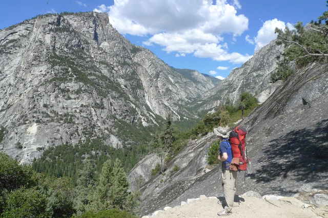
We hike up and over Kearsarge Pass (11845), and then past beautiful Bullfrog Lake. Beyond Bullfrog Lake the trail joins the JMT as it drops down to Vidette Meadow. We expected bumper to bumper traffic, but only met one solitary hiker. At Vidette Meadow we headed down Bubbs Creek to a spot just beyond Junction meadow (9000 feet) where we made camp. My knee is complaining (an all too familiar IT band pain) and saying this is enough for one day.
This trip is intended to be a forest hike (in contrast to my usual choice of timberline lakes and mountaineering). I am paying attention to identifying the different species of trees. As an aid to this, I am carrying the Laws Field Guide to the Sierra Nevada. A heavy extravagance (19 ounces!) so I am being sure to get all the use out of it that I can. There was a mix of Limber and Whitebark pines (with a few Lodgepoles) on the east side of Kearsarge Pass. Now that we are dropping below 9000 feet there are lots of fir. Hiked 8.5 miles.
Nighttime temperature at 9000 feet was 45 degrees. Cozy sleeping in dense forest.
I am finally feeling OK after getting two nights of decent sleep. Alex has developed a lot of nasty blisters and is having real trouble with his feet. I also am having an odd problem with a pain where a shoelace passes over a tendon on top of my foot. I fix this by relacing my shoes skipping a set of eyelets. Both of us are wearing running shoes and are surprised to be having problems, but it goes to show that hour after hour and day after day hiking is more demanding than a few hours of running.
We are following Bubbs Creek to the west and downhill through dense forest with great views down the canyon. We get a close look at Charlotte Dome (which I once intended to do a rock climb on). It is impressive, intimidating, and serious, not casual and friendly. A series of steep switchbacks with great views bring us down to the junction with the south fork of the Kings River. We cross on a big bridge, hide our packs, and run/walk to "Roads End". This allows us to boast that we crossed the Sierra Nevada on foot. The nice lady ranger there tells us that moisture and storms are expected later in the week. We return to our packs and are surprised that clouds and rain are developing at 4PM. Because of the rain, we set up camp about 1 mile above the junction.
This area is heavily regulated and must see heavy levels of use by people entering from the west. For us, we feel as if we are deep in the wilderness after hiking for two days, but the regulations are not aimed at us (exhausted after hiking all day from the east), but at the people who have just left their cars at Roads End. To our surprise camping is forbidden below Sphinx Trail Junction and at lower paradise valley and paradise valley you MUST camp in one of the three developed sites (with pit toilets!). Hiked 13.6 miles.
Nighttime temperature of 53 degrees at 5200 feet.
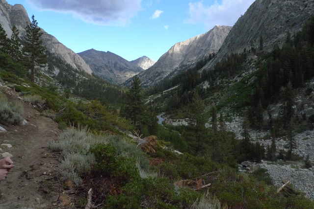
At Upper Paradise there is a big steel bridge over the Kings River. We meet a guy there who is drying his gear. He came in over Taboose Pass and down the Muro Blanco. He says he got 4 hours of rain and hail yesterday (much more than we got). He said the Muro Blanco is indeed rough, but he saw a group of 8 heading up. The brush forces you into the river, but the river is too dangerous. We cross the bridge and start up Woods Creek; hot and sweaty, but delighted to be out of the intensely regulated zone. Clouds build and worry us a little with thunder, but then settle down. We thought of camping at Castle Dome meadows, but it is dry and dusty with sagebrush, so on we go. Not too much farther we find a lovely spot on glacier polished slabs beyond a drift fence. Hiked 10.4 miles.
It is a beautiful night with stars and dew, 41 degrees at 8500 feet. We only get dew at higher and colder camps!
We hike up Woods creek about half a mile to the junction with the Muir trail and an amazing suspension bridge (the golden gate of the Sierra - one at a time please). Now we are on the JMT heading up the south fork of Woods Creek. As we climb to 9000 feet, things definitely have a more alpine feel, and it is refreshing. It is a breezy day with clouds moving in from the east. We arrive at Dollar Lake, both of us exhausted and dragging. We finally stop at 3:30 close to where the trail to 60 lakes basin leaves the JMT. Hiked 8.6 miles. We covered this distance in 6 hours (1.43 miles per hour).
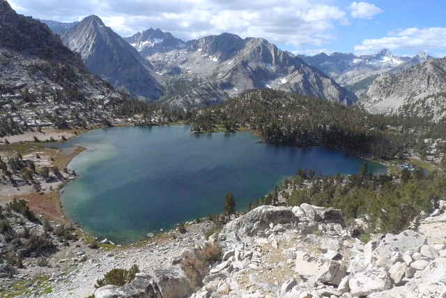
The entire Rae lakes area is beautiful. I see Mount Clarence King, but never get a look at Cotter - it is hidden behind Fin Dome. Dragon Peak is very impressive, as is the Painted Lady. One of my goals for the trip had been to visit 60 lakes basin. We met a couple of guys hiking out of there saying that it was incredible and that we really ought to invest an extra day and see it. Alex though has had enough with his blistered feet, and I have made up my mind to pay a visit myself in a future solo trip.
We decided to get up as early as there is enough light to see what we are doing, pack up and get on the trail. We do just that and tackle the climb up to Glenn Pass. We have decided that we are hiking out today, come what may. We are surprised to meet a fellow on Glenn Pass who spent the night there. He is an ultramarathon runner who is hiking the JMT in 7 days. His plan for the day is to finish, hiking (and running) all the way from Glenn Pass to Whitney Portal - expecting to exit at 3AM. He is a lively and fascinating character, carrying what looks like a day pack. I tell him I am thinking of hiking the JMT next year and he turns looks at me with an intense look, points his finger at me and says, "You need to do it!".
We part ways, him zooming ahead, pass a group of girls on their way up the other side, and cruise along over Kearsarge Pass and back to the trailhead, meeting several parties on their way up. A brisk cool wind is blowing from the east, and a change in the weather may be coming in as we are leaving.
Although Kearsarge Pass is probably one of the most heavily used areas in the Sierra, we did not find it busy at all - at least not in September. Hiked 11.5 miles
We were back at the truck in early afternoon. We drove to Lone Pine where we got a shower at the hostel and a pizza across the street. Then we drove to a camp spot on the Mojave Preserve, finishing the drive to Tucson on Saturday.
| Sunday | 2.5 miles |
| Monday | 8.5 miles |
| Tuesday | 13.6 miles |
| Wednesday | 10.4 miles |
| Thursday | 8.6 miles |
| Friday | 11.5 miles |
All told, we hiked 55 miles, covering an average of 10.5 miles each day. I exclude Sunday from this average, since it was just a couple of hours hiking in the afternoon to reach our first campsite. Also, I realize that our mileage on Tuesday was a bit inflated by the 4 mile loop we ran and walked to Roads End. I would like to say we did better, but there are the facts.
In part this is another artifact of the frantic week before leaving on the trip. But that is just an excuse, It really underscores something I have been trying to teach myself, namely to always check the settings before every important shoot. Scott Kelby has an acronym for this: "WHIMS"
This is a canister mandatory area, so we both carried bear canisters. A bear canister is, of course, the most hated item any backpacker can carry. We saw bear dung near Castle Dome Meadows and an actual bear below Paradise Valley, so bears are not mythical creatures after all. (This was the first time I have seen a bear in all my trips in the Sierra -- but all my other trips have been at timberline or above). A lady we spoke with said she saw a bear wander through middle Paradise camp, and emphasized how quiet it was moving around.
We began with 34 pound (Tom) and 32 pound (Alex) packs. We both felt that we were carrying too much weight, and we were. We exited with 29 pound 2 ounces (Tom) and 26 pound 3 ounce (Alex) packs. We began with Alex carrying the tent and ended with Tom carrying it.
I never want to carry more than 35 pounds ever. We carried 32-34 pound packs and our shoulders ached and got tired. Three weeks ago in Lone Pine Creek, we had 24 pound packs and it was effortless. I thought I would never say this, but I would rather have a lighter pack and risk being a little cold at night. The 15 degree rated Marmot Pinnacle sleeping bag was cozy down to 40 degrees and comfy enough to 30 degrees. Below 30 degrees is another realm. In truth though (and in partial justification) we both carried extra warm gear because we expected temperatures in the twenties every night in September above 10000 feet. We got lucky with great weather, and spent at least half of our time at significantly lower elevatons.
One thing in particular: we carried too much food. I began with 11 pounds of food and ended with 5 pounds, so I actually ate 1 pound per day for 6 days. My 11 pounds was based on 7 days at 1.6 pounds per day. We also decided mid trip to leave a day early (shortening the trip from 7 to 6 days) -- better to decide these things up front and lighten the pack. I have been steadily trimming my pounds per day guideline. The figure I began with was the ridiculous 2 pounds per day recommended by certain classic backpacking books - I quickly adjusted this to 1.6 pounds, but even this is too much food for me. On exit we met a fellow in the Onion Valley parking lot who told us that he does a no-cook food strategy and caries less than a pound per day! At this rate, 20 days of food would weigh less than pounds and no extra weight for stove, fuel, and utensils. This would make hiking the JMT without resupply a real possibility.
I am also convinced that my good planning overemphasizes carbohydrates. I need more fat for sure, and perhaps even more protein. At any rate, I have adjustments to make not just in the quantity of food. Fritos are great, and I may start carrying more chocolate like Andrew Skurka does.
Some things I never (or almost never) used and could have left behind:
One reason my weight got out of control is the week before leaving had me busy and exhausted repairing the fence at my house. Before a trip I need quality time to plan exactly what I am going to bring. What I ended up doing was gathering up my gear at the last minute and some things ended up in the pack "just in case".
The pleasure of going light has to be balanced against the risk of being cold at night. Light really is wonderful and pleasant, but I also do like to be cozy at night, and therin lies the dilemna. I need more warmth on my upper body than legs -- so some midweight capiline for the legs rather than R1 would be fine. The R1 hoodie up top is wonderful, and although I never used the down vest, it was good insurance against an unexpected cold night. A full blown down jacket might be the thing for below 30 weather. We were camping at lower than usual (for us) elevations, and the weather was very nice for mid September. It could have been a lot different.
I did not bring my hiking stick, but it would have been a real help on downhills. My IT Band began to hurt during Tuesdays downhill, and when I found a decent hiking stick, it was a big help.
I carried both the alcohol stove and the Bushbuddy, but only used the alcohol stove once (the day it rained). The Bushbuddy really is nicer. This might be lighter with a lighter pot.
We had a few mosquitos at every camp. We either ignore them or use the head-net. The Sierra had a record 200 percent snow year in 2011, and the usual conditions were delayed a month. September in 2011 was like August in typical years.
I carried the MLD Ark backpack for the extra volume (given the bear canister), and regretted not having the waist-band with the 35 pound load. I also regretted not having the waist band the last day of my Shepherd Pass trip (when I hiked over 20 miles).
Tom's hiking pages / tom@mmto.org