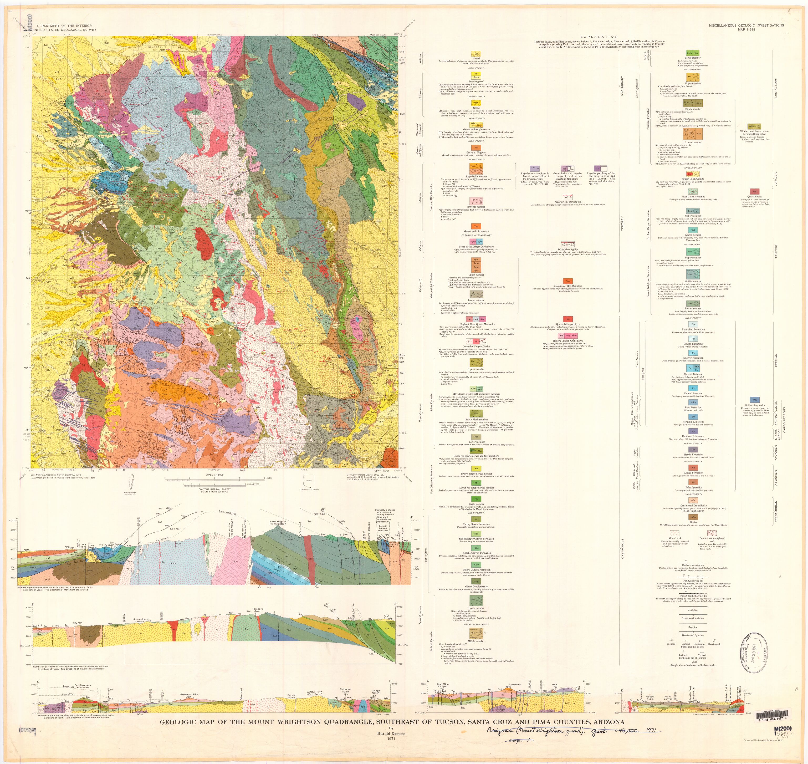
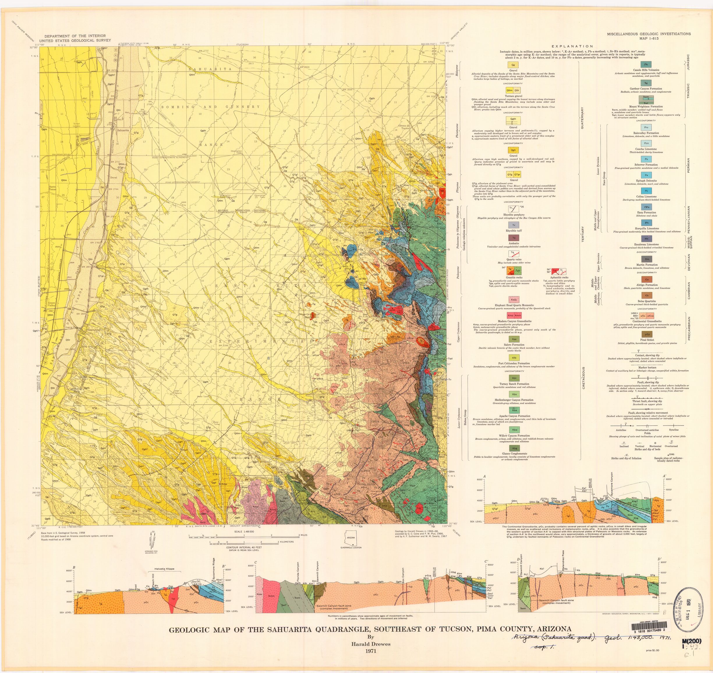
Drewes, Harald, 1971, Mesozoic stratigraphy of the Santa Rita Mountains, southeast of Tucson, Arizona:
U.S. Geological Survey Professional Paper 658-C, 81 p.
Drewes, 1972a, Cenozoic rocks of the Santa Rita Mountains, southeast of Tucson, Arizona:
U.S. Geological Survey Professional Paper 746, 66 p.
Drewes, 1972b, Structural geology of the Santa Rita Mountains, southeast of Tucson, Arizona:
U.S. Geological Survey Professional Paper 748, 35 p., scales 1:12,000 and 1:100,000, 4 sheets.
Drewes, 1981, Tectonics of southeastern Arizona:  U.S. Geological Survey Professional paper, v. 1144, p. 1-96.
Drewes, 1996, Geology of the Coronado National Forest, in du Bray, E.A., ed.,
Mineral resource potential and geology of Coronado National Forest, southeastern Arizona and southwestern New Mexico:
U.S. Geological Survey Bulletin 2083-B, p. 17-41, various scales, plates 1-4,
The USGS issued preliminary maps of the Empire Mountains quadrangle. When they said preliminary, they were not joking. These are scans in black and white of what look like someones field sheets. This is sad, but the existence of the very nice Mt. Fagan 7.5 map done by the Arizona Geological Survey in 2019 more than fills the gap for the part of the Santa Rita Mountains that is on the Empire Mountains sheet.
+--------+--------+--------+
+        +        +        +
+        +        +        +
+  ----  +  Tuc   +  ----  +
+        +        +        +
+        +        +        +
+--------+--------+--------+
+        +        +        +
+        +        +        +
+  Twin  +  Sahu  +  Empi  +
+        +        +        +
+        +        +        +
+--------+--------+--------+
+        +        +        +
+        +        +        +
+  Tuba  +  Mt-W  +  Elgi  +
+        +        +        +
+        +        +        +
+--------+--------+--------+
+        +        +        +
+        +        +        +
+  Ruby  +  Noga  +  Loch  +
+        +        +        +
+        +        +        +
+--------+--------+--------+
Full names are: Tucson, Twin Buttes, Sahuarita, Empire Mountains, Tubac, Mount Wrightson, Elgin, Ruby, Nogales, Lochiel.
The Mt. Fagan 7.5 minute sheet is the NW quarter of the Empire Mountain quadrangle. We would be happy to see the quad in the SW quarter, whatever its name might be.
Here is a partial layout of the 7.5 minute sheets. Note that Vail and "Rinc" are not on the Empire Mountain 15 minute sheet!
+--------+--------+
+        +        +
+        +        +
+  Vail  +  Rinc  +
+        +        +
+        +        +
+--------+--------+
+        +        +
+        +        +
+  Faga  +  Narr  +
+        +        +
+        +        +
+--------+--------+
+        +        +
+        +        +
+  ????  +  ????  +
+        +        +
+        +        +
+--------+--------+
The full names are: Vail, Rincon Peak, Mount Fagan, The Narrows.
Drewes, Harald, Fields, R.A., Hirschberg, D.M., and Bolm, K.S., 2002,
Spatial digital database for the tectonic map of southeast Arizona:
U.S. Geological Survey Miscellaneous Investigations Series Map I-1109,
Digital database, ver. 2.0, published scale 1:125.000,
2 sheets accessed September 9, 2012
I find these to be pretty much useless. They are very large scale and may have some value in giving regional context. To me they look like useless busywork done by some agency.
Tom's Geology Info / tom@mmto.org